ROUTE INSTRUCTIONS FOR DRIVING TO THE RIVER MOUNTAIN ACTION CAMP.
Route Instructions from Sacramento Intl Airport & points NORTH of Sacramento:
Exit your Terminal and proceed to the closest Rental Car Shuttle Bus Stop (on the island in front of the terminal) for a FREE ride to the Rental Car Terminal; Pick up the vehicle you have rented and follow the Exit signs to I-5 South. Then Follow signs to Sacramento. You will go South about 12 miles on I-5, then follow signs to Fresno and South Lake Tahoe onto I-80 for about a mile; Get into the Left Lanes and follow signs to Placerville and South Lake Tahoe and continue on I-50 for about 34 miles. Take Exit 37, "North Shingle Rd./Motherlode Dr.". Then follow the Map and the WEST of Placerville route Instructions.
Route Instructions from WEST or SOUTH of Sacramento:
Use your regular map of California to find your way to the intersection of the I-5 and I-80 (The South East side of Sacramento). Follow signs to South Lake Tahoe onto I-80 for about a mile; Get into the Left Lanes and follow signs to Placerville and South Lake Tahoe. Continue on I-50 for about 34 miles and take Exit 37, "North Shingle Rd./Motherlode Dr." Then follow the Map and the WEST of Placerville Instructions.
MAP Instructions from EAST of Placerville:
Take the first Placerville Drive exit from Hwy 50. Go Right at first Stop; Go Left at next Stop; Bear Right at next Stop; Stay on Cold Springs Rd. for about eight miles. Continue straight at the Stop ¼ mile past the "Vineyard House". You are now on the famous Hwy 49. Pass the general store on the left, and Turn Right onto New River Road just as Hwy 49 swings left in front of the old school house. Stay on the paved road and fork Left at the split. The American River Resort is at the end of the "New River Road". Follow signs to the RMA campsite.
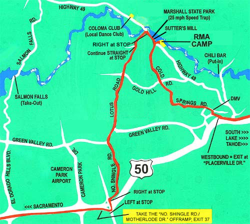
MAP Instructions from WEST of Placerville:
From the I-5 in Sacramento go East on Hwy 80 for about a mile. Follow signs to Placerville and So. Lake Tahoe (left lane) onto Hwy 50 for 34 miles. Take Exit 37, the "North Shingle Rd./Motherlode Dr." exit; Go Left at Stop over the freeway; Go Right at the next Stop; Stay on Shingle Springs Rdabout 6 miles; Bear right onto Green Valley Rd. and cross over a small, narrow bridge. Cont. over the larger bridge onto "Lotus Road". Stay on Lotus Road to the end. Right at "Stop" onto Hwy 49 (25 m.p.h. Speed Trap through Marshall State Park). Continue straight onto New River Road when Hwy 49 swings right just as you pass the old school house on your left. Stay on the paved road and fork Left at the split. The American River Resort is at the end of the "New River Road", (about 11 miles from the freeway). Follow signs to the RMA campsite.
|